Liquefying Edges in the Meadowlands Through Water-Informed Transect Planning
Program Management, Policy Research, Advocacy
Liquid Edges
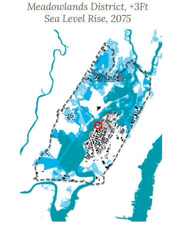
In 2100, the Meadowlands will have let the water in, but made sure to protect the community, the wetlands, and the economic engine of the region. To see this future, it is imperative that we connect the edge conditions of the three major land uses in a creative and future-proof way. The area must carefully stitch the edges, boundaries, and zones of Hackensack River with the surrounding community to respect (and reflect) the fact that water does not respect borders in the short, medium, and long term.
Rearranging Land Use
Between fragmented municipalities and fragmented wetlands, learning to make the land flexible with the water’s demands.
Problem Statement
Hackensack Riverkeeper is concerned with legacy; not only the legacy of their organization but also the legacy of the Hackensack River. For the founders of Riverkeeper to realize their goal of a fishable, swimmable waterway by 2100, the organization must engage with the current limitations to fostering and maintaining the next generations of stewards who can remain in place.
Fragmentation holds the Meadowlands District from making that future a reality by 2100, particularly in the face of sea level rise. The Meadowlands are segregated by hard edges and stark separations between the assets most precious to the area. Between living and working. People and nature. Community and their waterfront. Fragmentation exists at the political and land use levels as well. The Meadowlands District is made up of 14 municipalities across 2 counties, each with their own local priorities and policies.
Bridging divides is the key to unlocking the potential of the Hackensack and cementing the organization’s long-term sustainability.
One current solution can pose either an existential threat or create untapped opportunity. NJDEP’s Blue Acres program, one of the nation’s leading managed retreat programs, buys houses in repetitive loss areas. But the question emerges: once people sell, where do they go? And what does that mean for maintaining an engaged community to steward the river? In order to plan for and with Hackensack Riverkeeper, continuing community connections to and stewardship of the wetlands requires planning to minimize displacement and foster community that will live with water. Rebuilding with water through Blue Acres to elevate, densify, and reimagine land use is integral to envisioning a more radical, inclusive, and sustainable community in the Meadowlands, where reimagined planning and synergized long-term needs create an adaptable future for communities to thrive alongside the water. But how can we advocate for and reimagine zoning and borders that support innovative programs like Blue Acres? How can we create a framework robust enough to respond to the challenges of living with water, but accessible enough to speak for itself?
How can the area liquify these edges and come together for a more sustainable Meadowlands?
Current Land Use Hierarchy
The current fragmented land uses create a segregated, car-dependent, actively polluting Meadowlands District where residents are separated from the waterfront. To foster a fishable, swimmable river, people need to be connected to their greatest asset: the wetlands.
Residential
Residential land in the area makes up only 7% of overall land use, with 80% of that being in Secaucus alone. Secaucus has developed multifamily–Transit Oriented Developments (TODs) since 2004 that are separated from older, single-family zoned residential housing by transportation and industrial infrastructure, creating segmentation between communities of new renters and existing owners.
Industrial
Industry makes up 16% of land use in the Meadowlands District. Historically heavy industrial use has led to the creation of seven superfund sites along the river. Current use is generally for light manufacturing and warehousing from Secaucus up through North Bergen.
Open Space and Conservation
This category represents wetlands, recreation, and landfill and makes up almost half of the total land use in the district. Much of this land has been remediated and transitioned to usable recreation but still contains 107 Brownfield sites.
Current Transect Edge Conditions
The Meadowlands District’s 30.3 square miles are not easy to traverse, least of all by foot. Walking the district is perilous, and would take around 20hours. The river acts as a barrier rather than a connector, with only a few access points for recreational or transit-based movement along the water.
The built environment is small relative to the ever-growing wetlands, which expands by virtue of MCT purchases, landfill remediations, and other concerted efforts for natural preservation and wetlands conservation. Municipalities are separated by the river. Neighborhoods and their residents are separated by heavy transportation infrastructure, including the New Jersey Turnpike and Interstate-95. Privately owned and guarded roads and industrial properties line the wetlands, thwarting access.
Furthermore, due to a state ruling during the creation of the New Jersey Meadowlands Commission (1969), to prevent the Commission from superseding “home rule” governance, the District was not permitted to cover more than 80% of any of its 14 municipalities (NJSEA, 2024). For 13 of those municipalities, pre-existing hard barriers - the arterial highways – made for clear boundaries, and often left either wetlands or industry within the drawn District, with residential and commercial use upland and out of scope. Secaucus’ unique geography left it fully within District bounds. As a result, the Secaucus Township, with much of its residential use along a main street, opted out of District inclusion to avoid 100% zoning governance under the HDMC.
This township-shaped hole punch is seen in all Meadowlands District maps, and its exclusion in comprehensive planning documents gives a false sense of the true residential character of Secaucus and of the Meadowlands. Secaucus is notably the home of Hackensack Riverkeeper, and the local schools who make up their engaged youth groups.
The residents of Secaucus Township are also separated from the transit oriented developments that have been built around Secaucus Junction by pedestrian-unfriendly streets and industry. This has created disconnected communities of new renters from existing owners.
Fragmentation, stemming from land use and regulatory policies have created consequences for current residents that can be rectified by reimagining Secaucus as a connected neighborhood. The threat of sea level rise can be turned into an opportunity to restitch Secaucus into a walkable, thriving river city, with resilient residential redevelopments providing opportunities to live with water, avoid displacement, and house the community who will steward the river through 2100 and beyond.
Proposed Ecologically-Informed Transect Planning
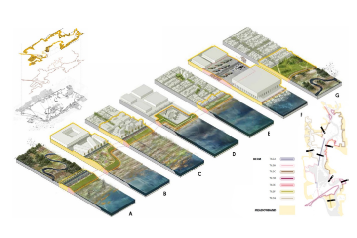
Rather than continuing the legacy of drawing segregated zones and boundaries that separate an area ruled by water, the Meadowlands could create flexible transect zones that flow with the liquid edges of the area and create a soft envelope around burgeoning land uses.
Rather than prescribing usage while leaving implementation vague, as is the case with standard Euclidean zoning, transect zoning can provide the flexibility to plan with climate change, which will likely not develop neatly as projected, while ensuring sustainable, human-centric urban design.
Traditional transect planning says buildings should perform in a certain way in to address the street. This vision urges that buildings should perform in a certain way in to address the water.
Precedent
Transect Planning/Zoning for Ecology
The idea of zoning around ecology rather than land use is not new, but it is radical. First proposed by Duany and Plater-Zyberk during the new urbanism movement, the theory focuses on “hierarchical geographic zones of urban or rural character rather than separated uses” (Walters, 2007). Transect planning follows the form of the nature. However, in the Meadowlands, what happens when nature is dynamic? This use of transect planning allows the definitions and goals of each area to be dictated by the evolving ecology of the area rather than arbitrary boundaries for dictating use.
source: Rebuild by Design
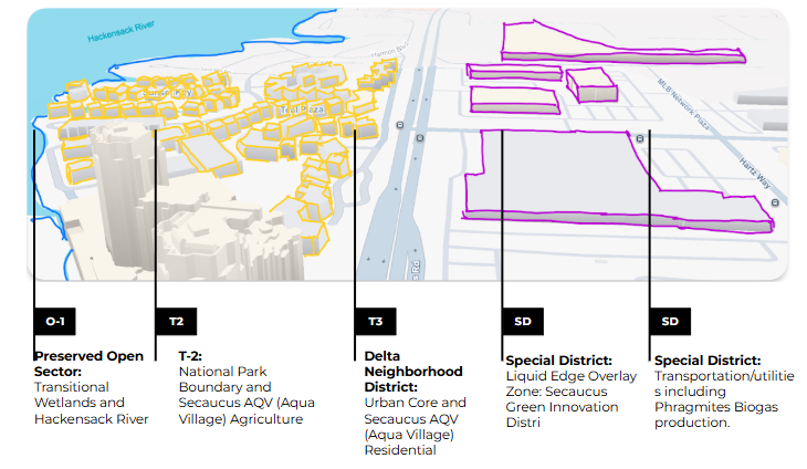
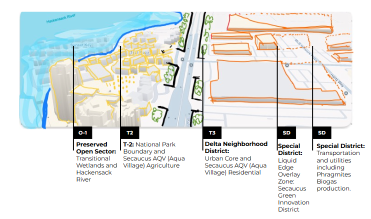
O-1 Preserved Open Sectors allow for protections at a regional scale.
T1 Natural Zones are typically designated and already protected lands including agricultural land, natural areas, wildlife habitats, and culturally significant sites.
T2 Rural Zones are often lands that should be protected or are planned to be protected in the future and also include agriculture, woodlands, future park lands.
T3 Sub Urban Zones consist of low density residential areas.
T4 General Urban Zones are comprised of mixed use, primarily residential areas/
TND (Traditional Neighborhood Development) Community Types nested within G3 Zones (Intended Growth Sectors) and contain transect Zones T3, T4, T5 (see appendix for details)
SD or special Districts are for areas with buildings that are organized by their function.
**Many areas will not conform to one transect zone or another and those can be identified as “transitional,” constituting places where the new transect zoning rules will allow them to evolve. (Center for Applied Transect Studies, Duany Plater-Zyberk & Company)
Ecologically-Informed Transect Planning Land Use Permissions
Planning to live with water requires strategically determining where water will dictate use versus where resilience measures and accommodations are more appropriate. In order to work with and not against nature, it’s imperative to connect neighborhoods to one another as well as to resources. This is best realized by densifying existing neighborhoods rather than leapfrog development, with communities separated by interstates, rivers, and other barriers.
Secaucus accounts for over 80% of the Meadowlands’ residential use (an undercount by NJSEA, which doesn’t account for Secaucus Township), and is connected to major cities like Jersey City, Hoboken, and Newark.
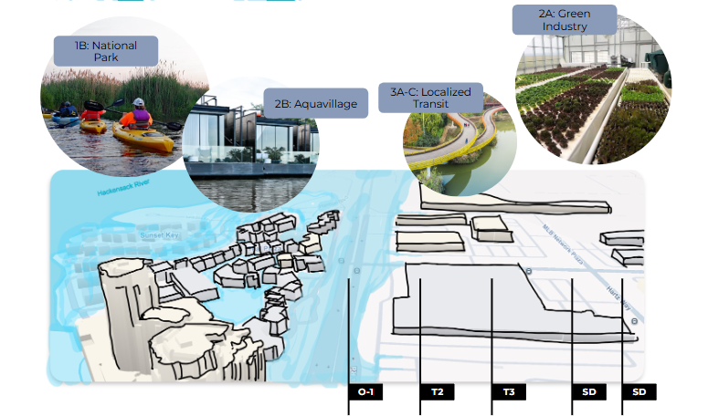
This recommendation is to make Secaucus a more connected, resilient community, and to create a thriving, walkable city on the banks of a critical asset: a clean river and a national recreation area (see recommendation: 1B).
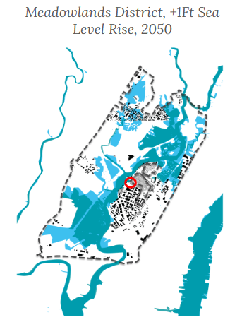
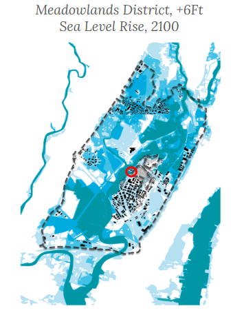
As sea levels rise, more radical interventions are needed to retain community. This involves activating the Blue Acres programs for elevations–of not just houses but of the streets–as well as marsh migration.
This is an opportunity to make Secaucus’ urban landscape more human-scale and navigable without automobiles by restitching flooded land to create a contiguous grid with increased density.
Transect Planning is the recommended model, as it regulates the relationships of the built environment to the streetscape (or in this case, the waterscape) for friendlier cities, and can allow Secaucus to scale with rising waters in ways that are consistent and provide contextual density and walkability. It also allows more complete neighborhoods by allowing corner stores and other amenities within residential communities.
By 2100, the Meadowlands will have strategically allowed water in to both protect and enhance community, the wetlands, and the economic engine of the region.
To see this future, it is imperative that the edge conditions of the three major land uses are connected in a more creative and future-proof way. The area must carefully stitch the edges, boundaries, and zones of Hackensack River with the surrounding community to respect (and reflect) the fact that water does not respect borders in the short, medium, and long term.
This progressive type of transect planning and zoning creates a flexible envelope that can respond to rising sea level and changing environments and creates a structure to support the following proposals more effectively.
Elevations of not just parcels but entire streetscapes can take many shapes depending on the existing topography and surrounding contexts. This can be simple landfill, or raised platforms that allow tidal waters to flow and native ecology to thrive.
Blue Acres already operates on a neighborhood model rather than individual parcels, and is well suited to raise entire neighborhoods in line with the most severe NOAA projected sea level rises (6ft). This process over time can lead to consistent, street/water-facing urban design through transect planning.
The gradual process can provide property owners with the opportunity to remain in place by elevating and rebuilding. Right to return contracts can ensure the return of existing residents rather than rebuilding for purely speculative purposes. Secaucus is well positioned to temporarily house residents throughout these modifications, as the 2020 Meadowlands Master Plan indicated the high concentration of hotels in Secaucus, a temporary housing solution used in right to return solutions such as the Gowanus Houses COMPMOD process (NYCHA, 2023).
By 2100, Secaucus can be a futurist, resilient, water-activated community, reimagined by rising waters and empowered to traverse by foot, bike, and boat.
It can house more than the next generation of Manhattan commuters, but a thriving, engaged community of Hackensack stewards, and the next cohorts of leadership for Hackensack Riverkeeper.